Dr. James Maxlow’s PHD Thesis
You can read Dr. Maxlow’s PHD thesis in its entirety at here
Abstract
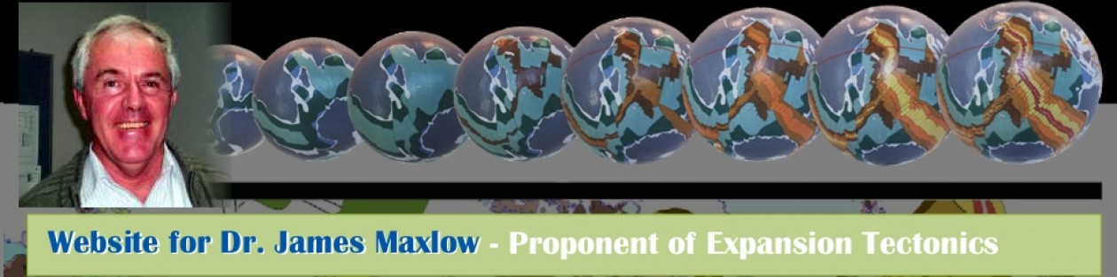
Global geological and geophysical data, while routinely used in conventional plate tectonic studies, has not been applied to models of an expanding Earth. Crustal reconstructions on Archaean to Recent models of an expanding Earth presented here are the first time that reconstructions have been extended back to the Archaean, and the first time that continental and oceanic geology has been utilised to constrain plate assemblage and palaeoradius of the Earth. A set of twenty four spherical models have been constructed, twenty three covering the Archaean to Recent and one projected to five million years into the future. Construction of these spherical models relies on the fundamental premise that crustal lithosphere is cumulative with time, and historical markers preserved in the oceanic and continental geology accurately constrain both palaeoradius and plate reconstruction from the Archaean to Recent.Post-Triassic reconstructions of oceanic lithosphere demonstrate a plate fit-together along each plate margin at better than 99% fit. During the Triassic, continents envelope the Earth as a complete continental shell at a reduced Earth radius, and marginal and epi-continental sedimentary basins merge to form a global network surrounding continental cratons and orogenic zones. Continental crust is reconstructed on Pre-Jurassic models using the primary crustal elements of cratons, orogens and basins, with expansion primarily manifested as crustal extension within an established network of epi-continental rifts, orogens and sedimentary basins. By removing all basin and pre-orogenic sediments a primordial proto-Earth at a palaeoradius of approximately 1700 kilometres is achieved during the Mesoproterozoic, comprising assembled cratons and Proterozoic basement rocks.
For all models, an intracratonic to intracontinental spatial integrity is maintained throughout Earth ++ history during processes of Precambrian and Palaeozoic continental crustal extension, Late Palaeozoic crustal rupture, Permo-Triassic continental break-up, and Mesozoic and Cenozoic continental dispersal to the Recent. Palaeomagnetic pole data delineate diametrically opposed palaeomagnetic pole clusters for each era back to the Archaean, without the need to consider random crustal dispersion-amalgamation-dispersal cycles. The palaeopole data is further supported by palaeogeographic, palaeobiogeographic, and palaeoclimatic indicators, which define palaeoequators and palaeoclimatic zones consistent with palaeomagnetic determinations. The distribution of latitude dependent lithofacies including glacigenic strata, carbonates, coal, and faunal and floral species is shown to coincide precisely with established palaeopoles and palaeoequators for all expanding Earth models.For climatic and biotic indicators a distinct latitudinal zonation paralleling the established palaeoequator is evident and a distinct northward shift in climatic zonation suggests that an inclined Earth rotational axis, inclined to the pole of the ecliptic, was well established during the Palaeozoic and persists to the Recent. Coastal geography on expanding Earth models shows that large Panthallassa, Tethys and Iapetus Oceans are not required during reconstruction. Instead, epi-continental Panthallassa and Iapetus Seas represent precursors to the modern Pacific and Atlantic Oceans and the Tethys Sea represents a precursor of the present Eurasian continent. Emergent land surfaces during the Precambrian and Phanerozoic equate to the conventional Rodinia, Gondwana and Pangaea supercontinents and smaller sub-continents, and demonstrate a spatial intracratonic and intracontinental integrity throughout Earth history.On each spherical model constructed proto-continental development is evolutionary and defined by ++ a progressive extension of epi-continental sedimentary basins, pulsed orogenesis, eustatic and transgression-regression of epi-continental seas, and opening of modern oceans during the Mesozoic to Recent.
Metallogenic modelling of Precambrian and Phanerozoic metal deposits shows a broad global Precambrian metallogenic provinciality coinciding with cratons and intracratonic settings, to regional provinces clustering as specific metal associations. The Phanerozoic metallogenic distribution highlights the abundance of porphyry and granite associated metals concentrated within Phanerozoic orogenic belts, and orogenic belts are shown to crosscut and displace pre-existing Palaeozoic and Precambrian metallogenic provinces.A proposed causal model for Earth expansion has expansion due to an exponential increase in mass with time. Earth expansion then involves an increase in mass by condensation, or segregation of new matter from the Earth’s core. This new matter accumulates at the core-mantle interface and the increase in volume results in a swelling of the mantle, which is then manifested in the outer crust as crustal extension. Matter generation within the Earth’s core is seen as an endothermic reaction, which will ultimately result in a decay of the matter formation process and cessation of expansion with time.
You can read Dr. Maxlow’s PHD Thesis in its entirety at here.