
The second model construction phase is more difficult to achieve because, while age dating the continental crusts exists in detail, its use in model construction is complicated by many overprinting phases of sedimentary deposition, erosion, metamorphism, and tectonism. During this extended interval of ancient time–around 3,750 million years, on an Expansion TectonicEarth there were also no preserved volcanic seafloor crusts to guide crustal assemblage.
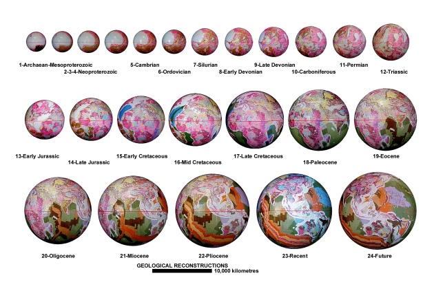
Spherical Archaean to future Expansion Tectonic small Earth models. Models show relative increase in Earth radii over time showing both continental and seafloor geology. Models range in age from the Archaean to the present-
Instead, during this construction phase an identified global network of continental sedimentary basins is used. During model construction, by moving back in time the radius of each succeeding model is progressively reduced in small, incremental stages. An equivalent area of the youngest sedimentary and magmatic rocks remaining is then removed from the model under construction and returned to the ancient lands or mantle–from where they originally came from.
This method is justifiable because the younger crustal rocks represent sedimentary and magmatic rocks that were deposited, intruded, or extruded after the older crustal rocks were first formed. During progressive removal of the younger rocks, each of the sedimentary basins are then restored to a pre-
This second modelling phase extends small Earth model coverage back in time, before the early-
While this outline of small Earth model construction may appear brief, the actual construction methodology is quite basic: the area of each coloured stripe or sedimentary basin is simply progressively removed in turn and the remaining crustal plates are re-
The method of constructing small Earth models adopted here results in a series of models that adhere precisely with the coloured time-
This modelling study empirically demonstrates that all continental crusts assemble as a complete Pangaean Earth at approximately 50 percent of the present Earth radius during the late-