
With the completion of the Geological Map of the World it is now a relatively easy process to determine ancient Earth radii using measured surface areas of seafloor crusts. The added advantage of this map is that the seafloor crusts have known ages, which are in turn used to accurately constrain the moment in time when these rocks were first formed.
The surface area of seafloor crustal stripes is established by digitising directly from the 24-
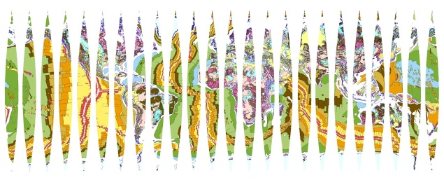
24-
This surface area data is then used to construct small Earth models at ancient radii coincident with the boundaries of each coloured stripe shown. These boundaries, in turn, represent the age distributions of each of the established geological epochs and periods. Models constructed for both seafloor and continental crusts are shown as red dots and squares in the ancient Earth radius graph below.
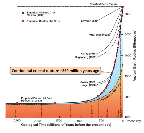
Exponential increases in Earth radius extending from the Archaean to present-
The presence of ancient Precambrian pink and red continental rocks shown in theGeological Map of the World suggests that a primordial small Earth may have existed at the beginning of geological time—around 4,000 million years ago. Since, on an Expansion Tectonic Earth, there were no, or very limited, volcanic seafloor crusts in existence during pre-
The method adopted here to determine a potential primordial Earth radius using continental sedimentary basins is basically very simple. During model construction, by moving back in time the radius of each succeeding model is progressively reduced in small, incremental stages. An equivalent area of the youngest sedimentary and magmatic rocks remaining is then removed from the model under construction. The established global network of sedimentary basins is then progressively reduced in surface area until only the most ancientPrecambrian continental crustal rocks remain.
This method is justifiable because the younger crustal rocks represent sedimentary and magmatic rocks that were deposited, intruded, or extruded after the older crustal rocks were first formed. During progressive removal of the younger rocks, each of the sedimentary basins are then restored to a pre-
By using this construction method an Archaean small Earth with a primordial Earth radius of about 1,700 kilometres can be readily constructed. This primordial small Earth is made up of an assemblage of the most ancient pink and red coloured Archaean crustal fragments, plus remnant khaki coloured early-
This 1,700 kilometre Earth radius, while subjective, represents an approximate limiting radius for the most ancient primordial Earth which can then be used to establish a mathematical formula to calculate Earth radius at any moment back or forward in geological time. From this primordial small Earth radius, mathematical modelling studies of Archaean to present-
The ancient Earth radius formula is expressed as:
Ra = (R0-
Where: Ra = the ancient Earth radius at time t, R0 = the present-